Understanding The Canadian Aids to Navigation System
Traffic Signals of the Waterways
The allure of boating draws new people to the waterways in Ontario every boating season. They look forward to fun-filled adventures and the feeling of freedom from their landlocked lives while cruising alongside pristine scenery with family and friends. With the freedom of charting a course on one of Ontario’s many gorgeous waterways, comes the responsibility of safe boating for both new and seasoned pleasure craft operators. The boating community is a tight knit group, and it’s everyone’s responsibility to ensure safe boating for all. Here is a quick guide to aids to navigation.
For novice boaters, it’s a whole new world when it comes to piloting a pleasure craft. Those accustomed to driving a car on Canadian roads will have to adapt to a different system of navigation.
The Canadian Aids to Navigation System
The Canadian Coast Guard is mandated to provide aids to navigation in Canadian waters. The Canadian Aids to Navigation System (also known as CANS), includes visual, aural (sound) and electronic aids that assist boaters with all aspects of navigation. This includes position and course, safest and preferred routes, warnings of dangers as well as non-regulatory information.
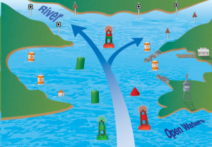
Image courtesy: boaterexam.com/canada
Lateral Aids
There are two main directions in boating: to open water and away from open water. For river boating, these directions are called downstream and upstream. Portside and Starboard side buoys mark the edges of the channel for the safest route to and from harbours.
Portside (left) and Starboard side (right) Buoys
Portside buoys are green and must be on the left side of the vessel, and starboard buoys are red and on the right side of the vessel. One helpful tip to remember is the phrase, “Red to Right when Returning,” the three R’s.
Junction Buoys
Chances are boaters will encounter a junction of two channels, indicating the preferred channel at the split. Junction buoys (aka bifurcation buoys) are painted both green and red, with the top color signalling the preferred channel.
Cardinal Buoys
Cardinal buoys are pillars or spars with black and yellow horizontal stripes. The colour pattern and the triangles (marks) on top tell you if the deepest or safest water is to the North, South, East, or West.
Special Purpose Buoys
Special purpose buoys cover different categories of information vital to boaters, including the following:
- Orange symbols on white pillars, cans or spar
- Information squares helpful to find food, supplies, repairs, give directions, distances
Other non-regulatory information
- Hazard diamonds informing of rocks, shoals, or turbulent waters
- Control circles indicating restricted boating areas such as no wake, idle speed, speed limit, or wash restrictions
- KEEP OUT! Crossed diamonds indicate areas where pleasure craft are prohibited such as dams and spillway.
Aural Aids
Aural aid devices produce sounds warning boaters of danger during low visibility conditions, and are operational when visibility is reduced to less than two nautical miles. These can be buoy mounted bells and whistles activated by wave action or fog signals on shore.
For the complete list of buoys and their purposes, please visit the Boat Canada Study Guide section titled “Traffic Signals of the Waterways”.
Electronic Aids
In addition to visual aids, it is a good idea to have some electronic aids on a vessel. Radar reflectors strengthen radar images of aids to navigation and radar beacons provide precise identification of the location they are marking using a coded radar image. Differential Global Positioning System (DGPS) improves the accuracy of the position derived from Global Position System (GPS) receivers by correcting the inherent inaccuracies of the GPS signal and comparing it to a known geographical position. Check with your local boating store on what options are best for your type of boating and budget.
Beyond the Buoys
New boaters, and experienced boaters should be reminded that the Canadian Aids to Navigation System is not the end all, be all navigation system to use while boating. Safely piloting a pleasure craft also involves the use of charts, magnetic compasses and GPS. Taking a navigation course to understand and correctly use nautical charts and a magnetic compass will improve the boating experience and prepare a boater for unfavorable weather conditions.
Magnetic Compass
If no land is in sight, or visibility is reduced, a boater must be able to steer the boat using a magnetic compass. It is recommended to practice using the magnetic compass during favorable weather conditions. A magnetic compass is an instrument that shows magnetic north, and should be placed away from iron, magnets and electrical equipment.
Nautical Charts
Pleasure craft operators must carry the most up to date nautical charts. Knowing water depth, type of shoreline, location of channels, coves, protected bays, underwater cables, bridges and other obstacles makes for a much safer boating experience.
There is much to learn before qualifying for a Pleasure Craft Operator Card in Canada. The following links provide boating information from the Canadian Government, as well as Transport Canada approved boating courses and study guides.
Online Resources:
Additional Blogs Resources
Top 10 Safety Practices to Avoid Injury and Death While Boating
Share


